By car and parking
- 2 car parks within 1 km
OpenStreetMap lists 2 car parks within 1 km of the beach. The nearest is about 6 minutes’ walk away (rough estimate, ignoring slopes). The fees of the others are not recorded.
Beach · Sant Josep de sa Talaia
Also known as sa Caleta
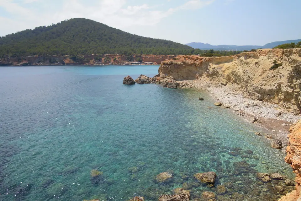
A gravel beach about 90 m long in Sant Josep de sa Talaia, isolated, with calm water and its mouth facing south-east. According to OpenStreetMap it is about a 6-minute walk from the nearest car park.
OpenStreetMap lists 2 car parks within 1 km of the beach. The nearest is about 6 minutes’ walk away (rough estimate, ignoring slopes). The fees of the others are not recorded.
Since April 2026 Ibiza’s buses have been run by ALSA. Lines whose names mention beaches in this area: A13 Es Cubells - Sant Josep, A14 Cala Bassa - Cala Tarida - Sant Josep, A15 Sant Josep - Cala Vedella, A7 Ibiza - Sant Jordi - Ses Salines, P3 Ibiza - Platja d’en Bossa - Ses Salines y P9 Cala Tarida - Sant Josep - Sant Jordi - Ibiza. Stops are not published with coordinates: check alsaibiza.es for the nearest stop and the timetable, which changes in winter.
Minutes from the nearest car park according to the OpenStreetMap map (rough estimate, ignoring slopes).
Some links are affiliate links: if you book, we may earn a commission at no cost to you. How affiliate links work
Average values for Ibiza (NOAA OISST, 1991-2020 climatology), not measured at this spot.
Sa Caleta opens to the south-east: with south-easterly, easterly, southerly, south-westerly or westerly winds, swell usually rolls in.
With northerly or north-westerly winds, by contrast, it is usually more sheltered.
This is a general orientation based on which way it opens, not a forecast: the shape of each coast changes it, so check the day’s weather before you go.
Trips and activities from our directory that include or stop at Sa Caleta. Each listing takes you to book on the platform you prefer.
Centro de Interpretación de Sa Caleta
Centre opened in 2025 beside the Phoenician village of Sa Caleta, with virtual routes and the story of the island's first stable settlement.
Closed on Mondays and Sundays according to Google
Guided MTB or e-MTB routes in the north, east, south and west, with a Formentera option.
Closed on Sundays according to Google
Where it is and which coves lie around it.
As the crow flies, nearest first.
More about Sant Josep de sa TalaiaArea: Sant Josep de sa TalaiaAll coves and beaches
OpenStreetMap lists 2 car parks within 1 km of the beach. The nearest is about 6 minutes’ walk away (rough estimate, ignoring slopes). The fees of the others are not recorded. About 6 minutes on foot · Easy path. Minutes from the nearest car park according to the OpenStreetMap map (rough estimate, ignoring slopes).
Since April 2026 Ibiza’s buses have been run by ALSA. Lines whose names mention beaches in this area: A13 Es Cubells - Sant Josep, A14 Cala Bassa - Cala Tarida - Sant Josep, A15 Sant Josep - Cala Vedella, A7 Ibiza - Sant Jordi - Ses Salines, P3 Ibiza - Platja d’en Bossa - Ses Salines y P9 Cala Tarida - Sant Josep - Sant Jordi - Ibiza. Stops are not published with coordinates: check alsaibiza.es for the nearest stop and the timetable, which changes in winter.
Sa Caleta opens to the south-east: with south-easterly, easterly, southerly, south-westerly or westerly winds, swell usually rolls in. With northerly or north-westerly winds, by contrast, it is usually more sheltered.
Our own text, based on these sources consulted on 2026-10-25. Dates, opening times and bus lines change: check them before you go.